

Aerial imagery does not generalize the content and is easy to interpret because it does not require any description or a legend. An ortho is a photogrammetric product that has recently gained significant popularity. But, what is hidden behind the notion of ‘true ortho’, so daringly entering the market?
Today, it is hard to imagine any geoportal without up-to-date aerial photos. The technological development of photogrammetric cameras and automation of ortho production have considerably expanded the scope of application of this type of data and attracted new users. Despite having an interesting rival in the form of laser scanning, both technologies seem to complement each other rather than compete.

Orthos in geodesy, which one to choose?
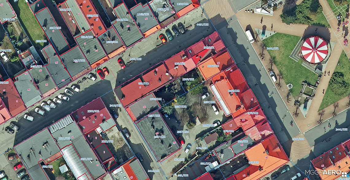
Practically every corner of Poland has an old or even historic infrastructure. It sometimes happens to be gradually enriched with modern buildings. Facility modernization or construction of a new object may take on an interesting and non-standard architectural form. As a result, it becomes quite a challenge for geodesists to present cadastral maps and keep them up-to-date. Layer of buildings is also an important element of the Land and Building Registry, just like the parcel boundaries. The contour lines of buildings in city centres with high-density housing very often converge with parcel boundaries. That is why the phenomenon of so called ‘buildings lean’ over a street is something geodesists tend to complain about. In such situation, true ortho seems to be a better solution. It is deprived of radial displacement, indicated by lean buildings or ‘blind spots’ – areas whose view is blocked by leant facilities.
So far, all orthos commissioned in Poland used to present objects correctly only to the ground level. Higher buildings were leaning considerably, obscuring the view of other interesting content. Actually, in most cases, the roofs found in the ortho were incompatible with orthogonal projection – they were moved relative to the ground. Such effect is even more conspicuous in orthos with better (e.g. 3-5 cm) resolution. From the geodetic point of view, it is considered to be ortho’s drawback. The higher the buildings, and bigger the distance between them and the image centre, the bigger radial displacement. Using wide-angle lens also contributes to the problem.

Advantage or drawback?
What some people think of as a disadvantage, others perceive as an asset. As for an ortho, the effect of lean buildings may also have some positive sides. Thanks to it, we can see at least one elevation that allows us to learn the number of storeys, compare them to the shadow cast by the building, and then determine quite precisely at least some parts of the facility’s ground floor.
The technology available on the market allows to minimize the negative effects of radial displacement – all you need is suitable selection of a camera and optics, which consequently results in enhancement of imagery mutual overlap. It must be remembered though that as far as enhanced longitudinal overlap does not affect the flight mission duration (only increases the photo strip), the extension of lateral overlap will significantly increase the price due to longer flight time and greater amount of photos.

How it works in practice
The enhanced mutual overlap allows creation of the true ortho. It is assumed that the minimum photo overlap, necessary for true ortho production, should not be lower than 80/60, with a tendency to extend the lateral overlap up to 80% in the case of higher built-up downtown areas. Such effect can be achieved through arranging extra strips.

Having properly-captured images, we can commence with data production. Solution presented in this article refers to fully-automated true ortho production. Manual works are limited to the minimum, although even such little involvement of the operator of photogrammetric station may influence the quality of the product. True ortho accuracy depends mainly on the Digital Terrain Model used during production. DTM quality, in turn, is dependent on algorithms, photo overlap, the accuracy of aerotriangulation and quality of all selected photos. Enhanced overlap between photos and photo strips, as well as proper quality of scenes are a guarantee of finding more homogenous points, which results in more accurate reflection of elements of spatial development.
In order to generate a proper product we need to draw special attention to elements such as: suitable flight mission planning, optimal conditions for taking images (time of flight, short shadows, light exposure, flight altitude, minor radial displacements), postprocessing and, finally, correction of aerial photo radiometry.
The first true ortho
Using large-format aerial imagery of Zory with 5-cm pixel, and ground control network measured via GNSS, we obtained aerotriangulation results with RMS accuracy: x = 3,3 cm, y=4,3 cm, z= 1,7 cm. This proves that we are able to create a true ortho, whose RMSE (root mean squared error) of point position nearly equals 1 pixel, meaning it fits within margin of sampling error. Buildings and other elements of spatial development, having minor distortion on the roof edges, are in actual and accurate metrical location, and the wall textures are not visible (orthogonal projection), which makes it possible to verify the mutual position or spatial relations (with determining the coordinates of details, even those from the first accuracy group).
Demanding technology
We should bear in minds that true ortho is a non-standard product. Present software does not always meet clients’ expectations who, in addition, have problems with defining the commissioned product. There are as many solutions and effects as software developers. It seems, at least for now, that true ortho is one of those products that should not be commissioned by means of public tenders. In my opinion, a client should have the possibility of pointing out a particular solution or even a particular contractor. It is hard to list explicitly the technical requirements that would guarantee obtaining a good-quality product. Maybe the ordering should be preceded by pilot projects?
Even the best true ortho will contain certain number of artefacts (noticeable flaws) visible while zooming in closer than the nominal scale. Manual correction, due to being time-consuming, is simply uneconomic. On the other hand, zooming at the scale smaller than 1:1 makes artefacts practically invisible.
To sum up, it can be said that the technology has some limitations, and its development may continue through the next few years. However, true ortho is prospective enough to become a standard product soon.
